Village of Saint-Sauveur de Peyre
#Discover
Nestled in the heart of the Terre de Peyre, Saint-Sauveur-de-Peyre is a village steeped in history and rich in a discreet yet authentic heritage. Here, every stone tells a story shaped by centuries, from the medieval charter to contemporary restorations.
A bit of history
The first mention of Saint-Sauveur-de-Peyre dates back to 1261. That year, a charter of liberties already mentions the existence of a church. The village then passed through the centuries, sometimes amidst turmoil.
In 1792, during the French Revolution, the inhabitants revolted. They defended their priest, refusing to see him replaced. This act of resistance left a lasting mark.
The church itself evolved over time. Deemed fragile and lacking artistic merit in the 19th century, it was finally rebuilt in 1876. Its large bell, named “Marie,” crowns the 30-meter bell tower.
Throughout the 20th century, the building continued to change. Renovations, modernization, lighting… Even today, the church remains at the heart of the village. It stands as a living testament to its history.


exploring the village
The Roc de Peyre
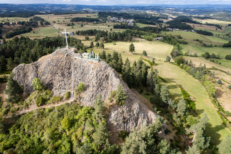
Dominating the Valley of Hell, the Roc de Peyre is a spectacular volcanic peak. It once housed a fortress, nicknamed the “Eagle’s Nest,” the seat of the Peyre barony. Considered impregnable, it was destroyed in the 15th century by Admiral Joyeuse. Today, a path leads to the summit. A viewpoint indicator offers a remarkable panoramic view. A parking area is located below.The Parish Church
The current church dates from 1876. It replaced an older wooden building that had become fragile. Simple yet symbolic, it houses a large bell donated by the local inhabitants. Restoration work was carried out until 2006, and the building has thus regained all its splendor.
Starting on foot from St-Sauveur
Looking to get some fresh air? Starting from Saint-Sauveur de Peure, two hiking trails will take you to discover the landscapes, forests, and viewpoints surrounding the town.
Download the detailed hiking guides for each route for free: distance, duration, difficulty level, trail markings… everything you need to plan your outing with complete peace of mind.